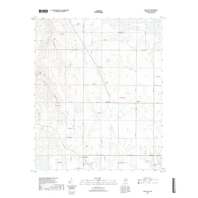
2018 Map of Palo Alto
USGS Topo · Published 2018About this map
Palo Alto and the surrounding rural landscape of Clay County are defined by a network of creeks and small family-named cemeteries that reflect generations of settlement. The terrain is marked by the winding paths of Houlka Cr, Line Cr, and Underwood Cr, while localized landmarks like Deans Lake and Reid Hill provide distinct geographic points of reference. The map documents numerous burial grounds, including the Palo Alto Cem, Saint Robertson Cem, and Rocky Hill Cem, which are essential for genealogical research in this part of Mississippi.
Find a feature on this map
65 named features on this map. Tap any name to fly to it.
Don’t see what you’re looking for? This feature index may not catch every label — zoom into the map to look around manually.
Map Details
Editions of this 2018 Palo Alto Map
This is the sole edition of this map. No revisions or reprints were ever made.
Other maps of this area

1953 · West Point
USGS Topo · 1:250,000

1958 · West Point
USGS Topo · 1:250,000

1959 · West Point
USGS Topo · 1:62,500

1959 · Van Vleet
USGS Topo · 1:62,500

1959 · Pheba
USGS Topo · 1:62,500

1963 · West Point
USGS Topo · 1:250,000

1966 · Prairie
USGS Topo · 1:24,000

1982 · West Point
USGS Topo · 1:100,000

1984 · West Point
USGS Topo · 1:250,000
1987 · Cedar Bluff
USGS Topo · 1:24,000