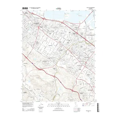
2015 Map of Palo Alto
USGS Topo · Published 2015About this map
Union Cemetery and Redwood Junction stand as historic anchors in a landscape defined by the dense residential growth of the mid-20th century Peninsula. This detailed survey documents the intricate interface between established towns like Redwood City and Menlo Park and the natural features of the foothills to the west. The geological presence of the San Andreas Fault cuts through the southwestern terrain near Portola Valley, providing a stark contrast to the engineered precision of the Hetch Hetchy Aqueduct and the Matadero Canal. Water systems are central to the area's development, with Searsville Lake, Bear Gulch Reservoir, and Felt Lake visible alongside the marshy reaches of Westpoint Slough and Ravenswood Slough near East Palo Alto. These features reveal a complex balance between massive suburban expansion and the preservation of open spaces like Jasper Ridge.
Find a feature on this map
80 named features on this map. Tap any name to fly to it.
Don’t see what you’re looking for? This feature index may not catch every label — zoom into the map to look around manually.
Map Details
Editions of this 2015 Palo Alto Map
This is the sole edition of this map. No revisions or reprints were ever made.
Other maps of this area

1892 · San Mateo
USGS Topo · 1:62,500

1896 · San Mateo
USGS Topo · 1:62,500

1897 · Palo Alto
USGS Topo · 1:62,500

1899 · Palo Alto
USGS Topo · 1:62,500

1899 · Haywards
USGS Topo · 1:62,500

1899 · San Mateo
USGS Topo · 1:62,500

1902 · Santa Cruz
USGS Topo · 1:125,000

1915 · San Mateo
USGS Topo · 1:62,500

1915 · Haywards
USGS Topo · 1:62,500

1939 · San Mateo
USGS Topo · 1:62,500