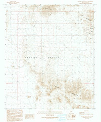
1990 Map of Palomas Mountains SW
USGS Topo · Published 1990About this map
Yuma Proving Ground dominates the central landscape of this desert corridor, a region defined by the arid transition between the Tank Mountains to the north and the Palomas Mountains to the south. The mapping reflects a landscape utilized for both military operations and mineral extraction. Gold mining history is evident in the eastern peaks, where the Golden Harp Mine sits alongside an Open Pit Mine, a Mine Shaft, and various prospects. This 1990 edition, based on earlier surveys and 1987 field checks, traces the intricate drainage patterns and 4wd tracks that provide the only access through this rugged corner of Yuma County. Water sources are scarce in this environment, with Mesquite Jim Well serving as a vital named landmark for those navigating the backcountry. The map captures a moment when the area remained largely undeveloped, preserved for defense testing and historical mining interests.
Find a feature on this map
10 named features on this map. Tap any name to fly to it.
Don’t see what you’re looking for? This feature index may not catch every label — zoom into the map to look around manually.
Map Details
Editions of this 1990 Palomas Mountains SW Map
This is the sole edition of this map. No revisions or reprints were ever made.
Other maps of this area

1928 · Norton
USGS Topo · 1:62,500

1929 · Norton
USGS Topo · 1:62,500

1930 · Stoval
USGS Topo · 1:62,500

1942 · Vicksburg
USGS Topo · 1:250,000

1950 · Stoval
USGS Topo · 1:62,500

1953 · Ajo
USGS Topo · 1:250,000

1954 · Phoenix
USGS Topo · 1:250,000

1955 · Roll
USGS Topo · 1:62,500

1957 · Ajo
USGS Topo · 1:250,000

1957 · Phoenix
USGS Topo · 1:250,000