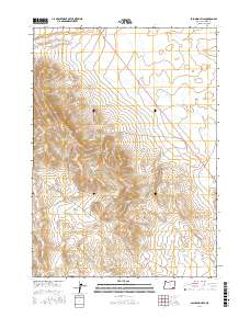
2017 Map of Palomino Hills
USGS Topo · Published 2017About this map
Palomino Hills and the surrounding high desert of Malheur County are defined by a sophisticated system of water management infrastructure essential for ranching and land use in this arid region. The 2017 landscape is punctuated by numerous artificial catchments, including Palomino Creek Reservoir, Two Day Reservoir, and Ridge End Reservoir. These features, alongside Lower Stockpile Reservoir, suggest a concentrated effort to harness seasonal runoff from drainages like Palomino Cr and Scott Butte Cr. The presence of the Big Basin and the intermittent flow of Drought Cr illustrate the challenging terrain that shaped local grazing boundaries and historical range management. This survey provides a precise look at the township and range divisions, showing how the land was subdivided for utility in the modern era.
Find a feature on this map
14 named features on this map. Tap any name to fly to it.
Don’t see what you’re looking for? This feature index may not catch every label — zoom into the map to look around manually.
Map Details
Editions of this 2017 Palomino Hills Map
This is the sole edition of this map. No revisions or reprints were ever made.
Other maps of this area

1955 · Jordan Valley
USGS Topo · 1:250,000

1955 · Adel
USGS Topo · 1:250,000

1957 · Adel
USGS Topo · 1:250,000

1957 · Jordan Valley
USGS Topo · 1:250,000

1958 · Adel
USGS Topo · 1:250,000

1958 · Jordan Valley
USGS Topo · 1:250,000

1962 · Adel
USGS Topo · 1:250,000

1972 · Palomino Hills
USGS Topo · 1:24,000
1972 · Palomino Lake
USGS Topo · 1:24,000
1972 · Iron Mountain
USGS Topo · 1:24,000