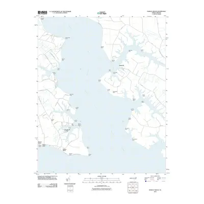
2010 Map of Pamlico Beach
USGS Topo · Published 2010About this map
The wide waters of the Pungo River dominate this coastal landscape, where the tides carve an intricate series of points and shores along the Beaufort County coast. Near the southern tip of the peninsula, the Wades Point Post Office stands as a focal point for the small communities of Wades Point and Pamlico Beach. The geography here is defined by low-lying necks and creek branches, most notably Tarkiln Neck and the bifurcated reach of North Prong Wright Creek and South Prong Wright Creek. These waterways once served as the primary transit corridors for timber and fishing interests, leading to landings such as Schoolhouse Landing and Makleyville. Dozens of family-named landmarks like Dave Moore Point, Harris Point, and July Point trace the shoreline, offering a clear view of how land ownership and local identity were tied to specific waterfront locations in this corner of North Carolina.
Find a feature on this map
79 named features on this map. Tap any name to fly to it.
Don’t see what you’re looking for? This feature index may not catch every label — zoom into the map to look around manually.
Map Details
Editions of this 2010 Pamlico Beach Map
This is the sole edition of this map. No revisions or reprints were ever made.
Other maps of this area

1914 · Belhaven
USGS Topo · 1:48,000

1916 · Belhaven
USGS Topo · 1:62,500

1943 · Columbia
USGS Topo · 1:125,000

1943 · Plymouth
USGS Topo · 1:125,000

1950 · Lowland
USGS Topo · 1:24,000

1950 · South Creek
USGS Topo · 1:24,000

1951 · Pamlico Point
USGS Topo · 1:24,000

1951 · Ransomville
USGS Topo · 1:24,000

1951 · Pamlico Beach
USGS Topo · 1:24,000

1951 · Belhaven
USGS Topo · 1:24,000