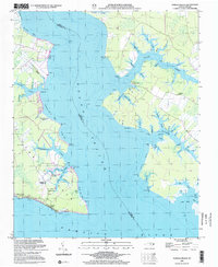
2002 Map of Pamlico Beach
USGS Topo · Published 2002About this map
Pungo River and Slade Creek dominate this coastal landscape at the convergence of Hyde and Beaufort counties. The map details a low-lying maritime environment defined by intricate waterways like Tarklin Creek and the expansive One Thousand Marshes. Cultural landmarks are centered around small waterfront settlements including Pamlico Beach and Makleyville, where the community's spiritual and social history is anchored by sites such as Pamlico Chapel and St Mahala Chapel.
Find a feature on this map
92 named features on this map. Tap any name to fly to it.
Don’t see what you’re looking for? This feature index may not catch every label — zoom into the map to look around manually.
Map Details
Editions of this 2002 Pamlico Beach Map
This is the sole edition of this map. No revisions or reprints were ever made.
Other maps of this area

1914 · Belhaven
USGS Topo · 1:48,000

1916 · Belhaven
USGS Topo · 1:62,500

1943 · Columbia
USGS Topo · 1:125,000

1943 · Plymouth
USGS Topo · 1:125,000

1950 · Lowland
USGS Topo · 1:24,000

1950 · South Creek
USGS Topo · 1:24,000

1951 · Pamlico Point
USGS Topo · 1:24,000

1951 · Ransomville
USGS Topo · 1:24,000

1951 · Pamlico Beach
USGS Topo · 1:24,000

1951 · Belhaven
USGS Topo · 1:24,000