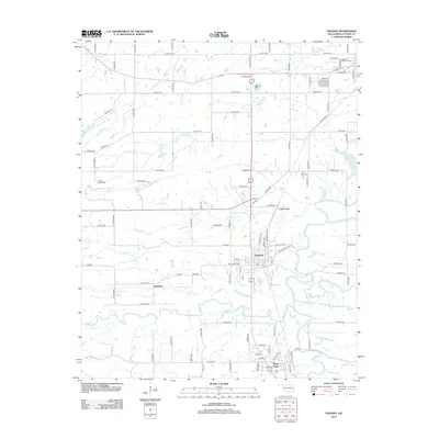
2012 Map of Panama
USGS Topo · Published 2012About this map
Panama sits at the heart of this Le Flore County landscape, where the confluence of the Poteau River and James Fork defines the local geography. The map reveals a region etched by water and history, with numerous tributaries like Brazil Cr and Buck Cr winding toward the main river channel. Smaller settlements such as Coal Creek and Bedwell are interspersed throughout the countryside, connected by an extensive grid of county roads. Genealogists will find several notable burial sites including Garden of Memories Cem near the northern boundary and Nubbin Ridge Cem to the west. The presence of tribal territory labels like Cherokee Choctaw Chickasaw Sequoyah reflects the deep cultural heritage of the area, while industrial and residential pockets around Shady Point indicate the modern development of these Oklahoma communities.
Find a feature on this map
90 named features on this map. Tap any name to fly to it.
Don’t see what you’re looking for? This feature index may not catch every label — zoom into the map to look around manually.
Map Details
Editions of this 2012 Panama Map
This is the sole edition of this map. No revisions or reprints were ever made.
Other maps of this area

1900 · Sallisaw
USGS Topo · 1:125,000

1911 · Sallisaw
USGS Topo · 1:125,000

1946 · Fort Smith
USGS Topo · 1:250,000

1965 · Fort Smith
USGS Topo · 1:250,000

1966 · Muldrow SW
USGS Topo · 1:24,000

1967 · Fort Smith
USGS Topo · 1:250,000

1967 · Robert S Kerr Dam
USGS Topo · 1:24,000
1967 · Fort Coffee
USGS Topo · 1:24,000
1968 · Spiro
USGS Topo · 1:24,000
1968 · Panama
USGS Topo · 1:24,000