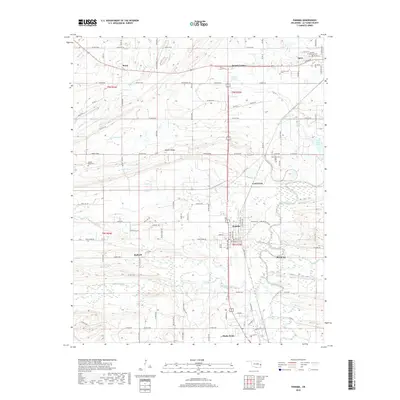
2018 Map of Panama
USGS Topo · Published 2018About this map
The Poteau River and its complex wetlands dominate this 2018 survey of LeFlore County, where the landscape transitions from the southern edge of Spiro down toward the city of Poteau. The town of Panama serves as a central hub, situated near the confluence of Coal Creek and Buck Creek. This area's topography is defined by the east-west orientation of Nubbin Ridge and the winding course of Brazil Creek. Local history is preserved through numerous rural burial grounds, including the Garden of Memories Cem and Nubbin Ridge Cem. The map illustrates a landscape shaped by water and transport, with the Midland Valley Rd and Co RD e1270 traversing the river valley. The presence of New Spiro Lake and Carter Lake alongside the river's meandering oxbows reflects the region's managed hydrography and agricultural drainage patterns.
Find a feature on this map
68 named features on this map. Tap any name to fly to it.
Don’t see what you’re looking for? This feature index may not catch every label — zoom into the map to look around manually.
Map Details
Editions of this 2018 Panama Map
This is the sole edition of this map. No revisions or reprints were ever made.
Other maps of this area

1900 · Sallisaw
USGS Topo · 1:125,000

1911 · Sallisaw
USGS Topo · 1:125,000

1946 · Fort Smith
USGS Topo · 1:250,000

1965 · Fort Smith
USGS Topo · 1:250,000

1966 · Muldrow SW
USGS Topo · 1:24,000

1967 · Fort Smith
USGS Topo · 1:250,000

1967 · Robert S Kerr Dam
USGS Topo · 1:24,000
1967 · Fort Coffee
USGS Topo · 1:24,000
1968 · Spiro
USGS Topo · 1:24,000
1968 · Panama
USGS Topo · 1:24,000