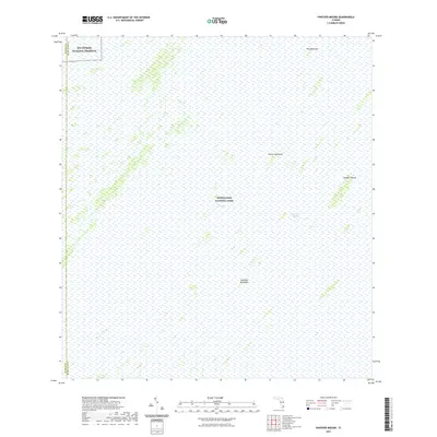
2021 Map of Panther Mound
USGS Topo · Published 2021About this map
Everglades National Park dominates this landscape, revealing a delicate network of tropical hardwood hammocks and slow-moving water in the southern interior of Florida. The terrain is defined by The Everglades and the wide, shallow drainage of the Shark River Slough, which facilitates the sheet flow of water across the limestone shelf. Named high points or "islands" of vegetation such as Panther Mound, Cane-Mill Hammock, and Guava Hammock serve as critical ecological anchors in an otherwise water-dominated environment. To the northwest, the boundary with Big Cypress National Preserve marks the transition between these two massive protected wetlands. This 2021 survey illustrates the remote character of the Monroe and Miami-Dade county line, where no roads or permanent human settlements appear, reflecting the state's commitment to preserving the original hydrologic character of this wilderness.
Find a feature on this map
9 named features on this map. Tap any name to fly to it.
Don’t see what you’re looking for? This feature index may not catch every label — zoom into the map to look around manually.
Map Details
Editions of this 2021 Panther Mound Map
This is the sole edition of this map. No revisions or reprints were ever made.
Other maps of this area

1956 · Miami
USGS Topo · 1:250,000

1958 · Miami
USGS Topo · 1:250,000

1972 · Shark Valley Lookout Tower
USGS Topo · 1:24,000

1972 · Lostmans Trail
USGS Topo · 1:24,000

1972 · Chekika Island
USGS Topo · 1:24,000

1972 · Long Pine Key
USGS Topo · 1:24,000

1972 · Panther Mound
USGS Topo · 1:24,000

1972 · Tarpon Bay
USGS Topo · 1:24,000

1972 · Indian Camp Creek
USGS Topo · 1:24,000

1972 · Pa Hay Okee Lookout Tower
USGS Topo · 1:24,000