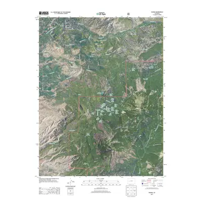
2013 Map of Paonia
USGS Topo · Published 2013About this map
The town of Paonia serves as the hub of this Colorado landscape, situated along the North Fork Gunnison River and surrounded by a network of agricultural mesas. High-altitude irrigation is central to the area's development, evidenced by the intricate system of gravity-fed waterways including Minnesota Ditch, Farmer Ditch, and Stewart Ditch. These diversions support the fertile lands of Pitkin Mesa, Lamborn Mesa, and Stewart Mesa, which are characteristic of the region's famous fruit-growing geography.
Find a feature on this map
95 named features on this map. Tap any name to fly to it.
Don’t see what you’re looking for? This feature index may not catch every label — zoom into the map to look around manually.
Map Details
Editions of this 2013 Paonia Map
This is the sole edition of this map. No revisions or reprints were ever made.
Other maps of this area

1938 · Mt. Gunnison
USGS Topo · 1:48,000

1945 · Mount Gunnison
USGS Topo · 1:62,500

1956 · Montrose
USGS Topo · 1:250,000

1959 · Montrose
USGS Topo · 1:250,000

1960 · Montrose
USGS Topo · 1:250,000

1964 · Minnesota Pass
USGS Topo · 1:24,000
1964 · Somerset
USGS Topo · 1:24,000
1965 · Gray Reservoir
USGS Topo · 1:24,000

1965 · Mount Guero
USGS Topo · 1:24,000
1965 · Paonia
USGS Topo · 1:24,000