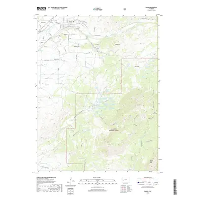
2019 Map of Paonia
USGS Topo · Published 2019About this map
Paonia sits at the northern edge of this landscape, where the North Fork Gunnison River and its tributaries support a complex irrigation network including the Farmers Ditch, Stewart Ditch, and Minnesota Ditch. The terrain quickly ascends from the agricultural flats of Pitkin Mesa and Lamborn Mesa into the high elevations of the Gunnison National Forest. This 2019 survey documents the intricate water management system essential to the region, featuring numerous named springs like Kauer Spring and Stephens Spring, alongside high-country water storage at Roeber Reservoir and Todd Reservoir. Rising above the mesas are significant peaks and ridges, most notably Mt Lamborn and Landsend Peak. For those researching local heritage, the map identifies established sites such as Bethlehem Cem and Cedar Hill Cem, as well as the path of the Jumbo Mountain Trail.
Find a feature on this map
93 named features on this map. Tap any name to fly to it.
Don’t see what you’re looking for? This feature index may not catch every label — zoom into the map to look around manually.
Map Details
Editions of this 2019 Paonia Map
This is the sole edition of this map. No revisions or reprints were ever made.
Other maps of this area

1938 · Mt. Gunnison
USGS Topo · 1:48,000

1945 · Mount Gunnison
USGS Topo · 1:62,500

1956 · Montrose
USGS Topo · 1:250,000

1959 · Montrose
USGS Topo · 1:250,000

1960 · Montrose
USGS Topo · 1:250,000

1964 · Minnesota Pass
USGS Topo · 1:24,000
1964 · Somerset
USGS Topo · 1:24,000
1965 · Gray Reservoir
USGS Topo · 1:24,000

1965 · Mount Guero
USGS Topo · 1:24,000
1965 · Paonia
USGS Topo · 1:24,000