
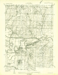
1934 Map of Papinsville
USGS Topo · Published 1934About this map
Papinsville and Prairie City anchor this 1934 topographic survey, which captures the complex river geography at the border of Bates and Vernon counties. The Mariais Des Cygnes River and Osage River dominate the central landscape, creating a labyrinth of water features including Mosley Bend, Camm Bend, and Helem Lake. For the local historian, the map identifies the Old Harmony Mission Site, reflecting early regional settlement patterns.
Find a feature on this map
72 named features on this map. Tap any name to fly to it.
Don’t see what you’re looking for? This feature index may not catch every label — zoom into the map to look around manually.
Map Details
Editions of this 1934 Papinsville Map
2 editions found
Other maps of this area

1886 · Nevada
USGS Topo · 1:125,000

1887 · Butler
USGS Topo · 1:125,000

1894 · Butler
USGS Topo · 1:125,000

1894 · Nevada
USGS Topo · 1:125,000

1934 · Rockville
USGS Topo · 1:24,000

1936 · Rich Hill
USGS Topo · 1:24,000

1938 · Horton
USGS Topo · 1:24,000

1939 · Horton
USGS Topo · 1:24,000

1939 · Eldorado Springs North
USGS Topo · 1:24,000
1939 · Harwood
USGS Topo · 1:24,000