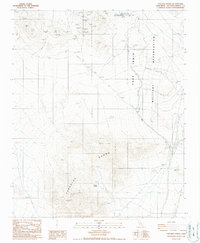
1986 Map of Paradise Range
USGS Topo · Published 1987About this map
The Fort Irwin Military Reservation dominates the eastern expanse of this high-desert landscape, a region defined by intense geological exploration and mid-century space-age infrastructure. Scientific advancement is evident at the Goldstone Deep Space Communications Complex, where specialized installations like Venus and Aries supported deep-space tracking efforts. This juxtaposition of frontier mining and modern technology is a hallmark of the area, as traditional excavations such as the Gold Divide Mine, Olympus Mine, and Rio Hondo Mine are scattered across the Paradise Range. Water sources remained vital for both industry and survival in this arid environment, marked by Paradise Springs, Hot Springs, and Jack Spring. The map documents a transition from the labor-intensive prospecting of the early 20th century to the large-scale military and aerospace operations that reshaped the California desert during the Cold War era.
Find a feature on this map
18 named features on this map. Tap any name to fly to it.
Don’t see what you’re looking for? This feature index may not catch every label — zoom into the map to look around manually.
Map Details
Editions of this 1986 Paradise Range Map
2 editions found
Other maps of this area

1933 · Avawatz Mountains
USGS Topo · 1:250,000

1947 · Trona
USGS Topo · 1:250,000

1948 · Trona
USGS Topo · 1:250,000

1948 · Alvord Mountain
USGS Topo · 1:62,500

1948 · Lane Mountain
USGS Topo · 1:62,500

1948 · Goldstone Lake
USGS Topo · 1:62,500

1948 · Tiefort Mountains
USGS Topo · 1:62,500

1951 · Goldstone Lake
USGS Topo · 1:62,500

1951 · Tiefort Mountains
USGS Topo · 1:62,500

1951 · Alvord Mountain
USGS Topo · 1:62,500