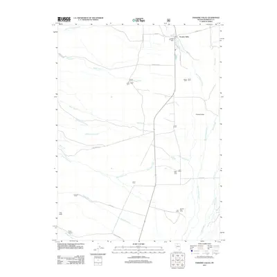
2011 Map of Paradise Valley
USGS Topo · Published 2011About this map
Paradise Valley serves as the primary hub of activity in this northern Nevada ranching landscape, positioned where several drainages descend toward the desert floor. The settlement is centered near the Paradise Valley Post Office, surrounded by a wide network of established family ranching operations. The map details a landscape shaped by water management, where Big Cottonwood Creek, Martin Creek, and Singas Creek flow through the valley, supported by features like Adams Slough. To the west, the terrain rises toward Trap Butte and Provo Canyon, while the valley floor is dotted with long-standing homesteads including Stone House, the Casinelli Ranch, and the Ferraro Ranch. This 2011 survey documents the persistent agricultural and livestock-focused layout of the region, where roads like Abel Creek Rd and Signas Creek Rd connect these outlying properties to the valley center.
Find a feature on this map
41 named features on this map. Tap any name to fly to it.
Don’t see what you’re looking for? This feature index may not catch every label — zoom into the map to look around manually.
Map Details
Editions of this 2011 Paradise Valley Map
This is the sole edition of this map. No revisions or reprints were ever made.
Other maps of this area

1882 · Paradise
USGS Topo · 1:250,000

1893 · Paradise
USGS Topo · 1:250,000

1945 · Hot Springs
USGS Topo · 1:62,500

1947 · Hot Springs Peak
USGS Topo · 1:62,500

1955 · McDermitt
USGS Topo · 1:250,000

1958 · Paradise Valley
USGS Topo · 1:62,500

1959 · McDermitt
USGS Topo · 1:250,000

1959 · Hinkey Summit
USGS Topo · 1:62,500

1980 · Spring City
USGS Topo · 1:24,000
1985 · Osgood Mts
USGS Topo · 1:100,000