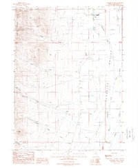
1988 Map of Paradise Valley
USGS Topo · Published 1989About this map
Paradise Valley sits at the northern edge of this Great Basin landscape, where the alluvial plain meets the rising peaks of the Humboldt National Forest. In the late 1980s, the community remained centered around its local Cem and essential infrastructure like a Landing Strip, reflecting the isolation and self-sufficiency of Nevada's high desert settlements. Water management defines the valley floor, where Big Cottonwood Creek and Martin Creek feed into a network of drainages including Adams Slough and various unnamed ditches.
Find a feature on this map
26 named features on this map. Tap any name to fly to it.
Don’t see what you’re looking for? This feature index may not catch every label — zoom into the map to look around manually.
Map Details
Editions of this 1988 Paradise Valley Map
This is the sole edition of this map. No revisions or reprints were ever made.
Other maps of this area

1882 · Paradise
USGS Topo · 1:250,000

1893 · Paradise
USGS Topo · 1:250,000

1945 · Hot Springs
USGS Topo · 1:62,500

1947 · Hot Springs Peak
USGS Topo · 1:62,500

1955 · McDermitt
USGS Topo · 1:250,000

1958 · Paradise Valley
USGS Topo · 1:62,500

1959 · McDermitt
USGS Topo · 1:250,000

1959 · Hinkey Summit
USGS Topo · 1:62,500

1980 · Spring City
USGS Topo · 1:24,000
1985 · Osgood Mts
USGS Topo · 1:100,000