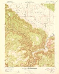
1949 Map of Paradox
USGS Topo · Published 1949About this map
Paradox Valley and the surrounding high country appear here during a period of significant geological interest, documented in part by the United States Atomic Energy Commission. The landscape is dominated by massive flat-topped formations, including Sinwanger Mesa, Wray Mesa, and Skein Mesa, which tower over the deep winding gorge of the Dolores River. The settlement of Paradox sits near the head of its namesake creek, while the village of Bedrock occupies a strategic position where the river meets the valley floor.
Find a feature on this map
14 named features on this map. Tap any name to fly to it.
Don’t see what you’re looking for? This feature index may not catch every label — zoom into the map to look around manually.
Map Details
Editions of this 1949 Paradox Map
2 editions found
Other maps of this area

1885 · La Sal
USGS Topo · 1:250,000

1916 · Paradox Valley
USGS Topo · 1:125,000

1922 · Paradox Valley
USGS Topo · 1:125,000

1948 · Roc Creek
USGS Topo · 1:24,000

1948 · Bull Canyon
USGS Topo · 1:24,000

1948 · Paradox
USGS Topo · 1:24,000

1949 · Bull Canyon
USGS Topo · 1:24,000

1949 · Davis Mesa
USGS Topo · 1:24,000

1949 · Paradox
USGS Topo · 1:24,000

1949 · Roc Creek
USGS Topo · 1:24,000