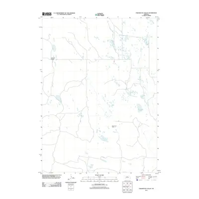
2011 Map of Paramount Valley
USGS Topo · Published 2011About this map
Paramount Valley and the surrounding Nebraska Sandhills are mapped here in detail, showing a landscape defined by its isolated settlements and numerous small, scattered water bodies. The terrain is characterized by winding local roads that connect remote points such as Johnsons Corner in the northwest. Much of the eastern portion of the quadrangle is drained by Skull Creek, which flows past Hornburger Lake. This 2011 survey captures the area's transition between managed ranch land and the natural hydrology of the plains, where small marshes and ponds dot the depressions between low rises. It provides a precise record for those studying the rural infrastructure and land use patterns of Brown County in the early 21st century.
Find a feature on this map
4 named features on this map. Tap any name to fly to it.
Don’t see what you’re looking for? This feature index may not catch every label — zoom into the map to look around manually.
Map Details
Editions of this 2011 Paramount Valley Map
This is the sole edition of this map. No revisions or reprints were ever made.
Other maps of this area

1955 · O'Neill
USGS Topo · 1:250,000

1959 · O'Neill
USGS Topo · 1:250,000

1969 · O'Neill
USGS Topo · 1:250,000

1981 · Boiling Spring
USGS Topo · 1:24,000
1981 · Shovel Dot Ranch
USGS Topo · 1:24,000

1981 · Paramount Valley
USGS Topo · 1:24,000

1981 · Rose
USGS Topo · 1:24,000

1982 · Raven
USGS Topo · 1:24,000
1982 · Goldman Lake SE
USGS Topo · 1:24,000
1982 · Goldman Lake NE
USGS Topo · 1:24,000