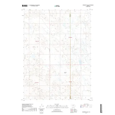
2017 Map of Paramount Valley
USGS Topo · Published 2017About this map
Paramount Valley occupies a distinct landscape defined by the sandy basins and ridge formations characteristic of the Nebraska Sandhills. This 2017 survey details the remote cattle country spanning the boundary of Brown and Rock counties, where the local economy and geography center on scattered water resources. The presence of Hornburger Lake and the drainage of Skull Creek in the eastern section indicate the vital importance of surface water in this arid ranching environment. Large-scale section mapping reveals a sparse infrastructure, with Eagle Point Ave serving as a primary north-south artery through the rolling terrain. The map's layout of townships and ranges, including t26n r21w and t25n r20w, illustrates the enduring structure of the Public Land Survey System in defining property and management lines in this open range land.
Find a feature on this map
9 named features on this map. Tap any name to fly to it.
Don’t see what you’re looking for? This feature index may not catch every label — zoom into the map to look around manually.
Map Details
Editions of this 2017 Paramount Valley Map
This is the sole edition of this map. No revisions or reprints were ever made.
Other maps of this area

1955 · O'Neill
USGS Topo · 1:250,000

1959 · O'Neill
USGS Topo · 1:250,000

1969 · O'Neill
USGS Topo · 1:250,000

1981 · Boiling Spring
USGS Topo · 1:24,000
1981 · Shovel Dot Ranch
USGS Topo · 1:24,000

1981 · Paramount Valley
USGS Topo · 1:24,000

1981 · Rose
USGS Topo · 1:24,000

1982 · Raven
USGS Topo · 1:24,000
1982 · Goldman Lake SE
USGS Topo · 1:24,000
1982 · Goldman Lake NE
USGS Topo · 1:24,000