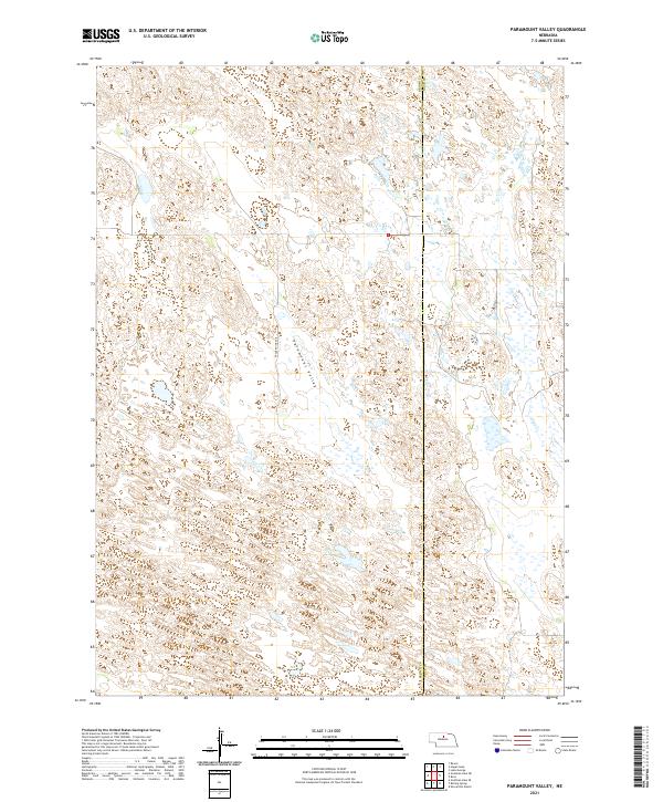
2021 Map of Paramount Valley
USGS Topo · Published 2021About this map
Paramount Valley defines this section of the Nebraska Sandhills, where the undulating terrain is marked by numerous small wetlands and depressions. The landscape is sparsely populated and primarily organized by the Public Land Survey System, as seen in the grid of sections across t26n r21w and t26n r20w. This 2021 survey documents a remote agricultural environment where movement is dictated by the natural drainage of Skull Cr and a few maintained corridors like Eagle Point Ave. The boundary between Brown Co Rock Co runs north-south through the eastern portion of the map, providing a clear reference for local land records and property research in this rural region.
Find a feature on this map
8 named features on this map. Tap any name to fly to it.
Don’t see what you’re looking for? This feature index may not catch every label — zoom into the map to look around manually.
Map Details
Editions of this 2021 Paramount Valley Map
This is the sole edition of this map. No revisions or reprints were ever made.
Other maps of this area

1955 · O'Neill
USGS Topo · 1:250,000

1959 · O'Neill
USGS Topo · 1:250,000

1969 · O'Neill
USGS Topo · 1:250,000

1981 · Boiling Spring
USGS Topo · 1:24,000
1981 · Shovel Dot Ranch
USGS Topo · 1:24,000

1981 · Paramount Valley
USGS Topo · 1:24,000

1981 · Rose
USGS Topo · 1:24,000

1982 · Raven
USGS Topo · 1:24,000
1982 · Goldman Lake SE
USGS Topo · 1:24,000
1982 · Goldman Lake NE
USGS Topo · 1:24,000