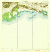
1938 Map of Parguera
USGS Topo · Published 1938About this map
Sierra Bermeja dominates the northern skyline of this coastal survey, where the rugged hills of Lajas meet the Caribbean Sea. The shoreline is a complex network of mangrove-fringed points and cays, ranging from Pta Pitahaya in the west to the deeply indented Bahia Montalva (Puerto Nuevo) in the east. At this time, the fishing village of Parguera is a small collection of structures near the water, supported by the inland Escuela Ramon Baldorioty de Castro and the salt-harvesting operations at Salinas El Papayo. The map reveals a pre-industrial coastal economy where movement was dictated by the Carretera No 39 and small tracks leading to landholdings like Cabezon Rancho. Off the coast, numerous islands such as Isla Maguey and Isla Guayacan protected the shallows, while the peaks of Cerro Vertero provided vital landmarks for navigation along the southern coast of Puerto Rico.
Find a feature on this map
29 named features on this map. Tap any name to fly to it.
Don’t see what you’re looking for? This feature index may not catch every label — zoom into the map to look around manually.
Map Details
Editions of this 1938 Parguera Map
4 editions found
Other maps of this area

1935 · Puerto Real
USGS Topo · 1:25,000

1937 · San German
USGS Topo · 1:25,000

1937 · Sabana Grande
USGS Topo · 1:25,000

1937 · Puerto Real
USGS Topo · 1:25,000

1938 · Guanica
USGS Topo · 1:30,000

1938 · Parguera
USGS Topo · 1:30,000

1938 · Cabo Rojo
USGS Topo · 1:30,000

1941 · San German
USGS Topo · 1:30,000

1941 · Puerto Real
USGS Topo · 1:30,000

1941 · Sabana Grande
USGS Topo · 1:30,000