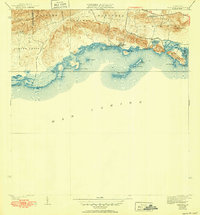
1938 Map of Parguera
USGS Topo · Published 1952About this map
Parguera is the focal point of this coastal survey, where the rugged slopes of the Sierra Bermeja meet the shallow, island-studded waters of the Mar Caribe. The map illustrates a landscape shaped by coastal salt production and traditional agriculture, most notably at the Salinas El Papayo and the inland Rancho Cabassa. The shoreline is remarkably complex, defined by numerous points like Pta Pitahaya and a protective chain of cays including Cayo Enrique and Isla Maguey.
Find a feature on this map
35 named features on this map. Tap any name to fly to it.
Don’t see what you’re looking for? This feature index may not catch every label — zoom into the map to look around manually.
Map Details
Editions of this 1938 Parguera Map
4 editions found
Other maps of this area

1935 · Puerto Real
USGS Topo · 1:25,000

1937 · San German
USGS Topo · 1:25,000

1937 · Sabana Grande
USGS Topo · 1:25,000

1937 · Puerto Real
USGS Topo · 1:25,000

1938 · Guanica
USGS Topo · 1:30,000

1938 · Parguera
USGS Topo · 1:30,000

1938 · Cabo Rojo
USGS Topo · 1:30,000

1941 · San German
USGS Topo · 1:30,000

1941 · Puerto Real
USGS Topo · 1:30,000

1941 · Sabana Grande
USGS Topo · 1:30,000