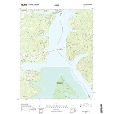
2019 Map of Paris Landing
USGS Topo · Published 2019About this map
Kentucky Lake and the Tennessee River divide this landscape where Henry and Stewart counties meet at the Tennessee and Kentucky border. The shoreline is defined by deeply recessed inlets like Swan Bay and Piney Bay, while the northern edge includes a portion of Fort Donelson National Battlefield. The western shore is more densely settled, centered on Paris Landing and Oak Hill, with a high concentration of small family and community burial grounds, including Old Moody Cem and Point Pleasant Cem. To the south, the protected landscape of the Tennessee National Wildlife Refuge encompasses the area around Pace Point and Robertson Lake. The eastern bank is marked by numerous named hollows, such as Mullins Hollow and Rattlesnake Hollow, suggesting a more dissected and less developed terrain compared to the developed communities across the water.
Find a feature on this map
152 named features on this map. Tap any name to fly to it.
Don’t see what you’re looking for? This feature index may not catch every label — zoom into the map to look around manually.
Map Details
Editions of this 2019 Paris Landing Map
This is the sole edition of this map. No revisions or reprints were ever made.
Other maps of this area

1936 · Poplar Creek
USGS Topo · 1:24,000

1936 · Buchanan
USGS Topo · 1:24,000

1936 · Tharpe
USGS Topo · 1:24,000

1936 · New Concord
USGS Topo · 1:24,000

1936 · McKinnon
USGS Topo · 1:24,000

1936 · Hamlin
USGS Topo · 1:24,000

1936 · Centerville Landing
USGS Topo · 1:24,000

1936 · Standing Rock
USGS Topo · 1:24,000

1936 · Springville
USGS Topo · 1:24,000

1938 · Springville
USGS Topo · 1:24,000
Featured Places
- Durham Subdivision, TN
- Oak Wood Estates, TN
- Buchanan Subdivision, TN
- Cabana Estates, TN
- Oak Haven Acres, TN