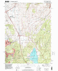
1999 Map of Park City East
USGS Topo · Published 2001About this map
Jordanelle State Park and the expansive Jordanelle Reservoir dominate the southeastern landscape of this late 20th-century survey, illustrating the significant hydraulic and recreational infrastructure east of the Wasatch Range. The map captures a moment of transition as the region prepared for global attention, specifically noting the Deer Valley Resort as a designated 2002 Olympic site.
Find a feature on this map
42 named features on this map. Tap any name to fly to it.
Don’t see what you’re looking for? This feature index may not catch every label — zoom into the map to look around manually.
Map Details
Editions of this 1999 Park City East Map
This is the sole edition of this map. No revisions or reprints were ever made.
Other maps of this area

1885 · Salt Lake
USGS Topo · 1:250,000

1900 · Coalville
USGS Topo · 1:125,000

1903 · Coalville
USGS Topo · 1:125,000

1925 · Ft. Douglas
USGS Topo · 1:125,000

1928 · Ft. Douglas
USGS Topo · 1:125,000

1954 · Salt Lake City
USGS Topo · 1:250,000

1955 · Heber
USGS Topo · 1:24,000

1955 · Park City East
USGS Topo · 1:24,000

1955 · Brighton
USGS Topo · 1:24,000

1955 · Park City West
USGS Topo · 1:24,000