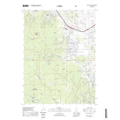
2020 Map of Park City West
USGS Topo · Published 2020About this map
The Wasatch National Forest dominates the western half of this 2020 landscape, where the high peaks of the Wasatch Range create a dramatic backdrop for the growing communities of the Snyderville Basin. The transition from the steep, canyon-riven terrain of Murdock Peak and Scott Hill to the valley floor at Parleys Park illustrates the geographic divide between protected wilderness and residential expansion. Along the eastern corridor, the development cluster at Kimball Junction and the historic settlement of Snyderville serve as modern hubs, while the southern edge of the map touches the residential outskirts and industrial history of Park City. The map documents a complex network of recreational trails like the Mid Mountain Trail weaving through drainages such as Threemile Canyon and Thaynes Canyon, reflecting the area's evolution from a mining district to a premiere outdoor destination. High-altitude water bodies including Lake Salamander and Red Pine Lake remain preserved within the national forest boundaries.
Find a feature on this map
55 named features on this map. Tap any name to fly to it.
Don’t see what you’re looking for? This feature index may not catch every label — zoom into the map to look around manually.
Map Details
Editions of this 2020 Park City West Map
This is the sole edition of this map. No revisions or reprints were ever made.
Other maps of this area

1885 · Salt Lake
USGS Topo · 1:250,000

1900 · Coalville
USGS Topo · 1:125,000

1903 · Coalville
USGS Topo · 1:125,000

1925 · Ft. Douglas
USGS Topo · 1:125,000

1928 · Ft. Douglas
USGS Topo · 1:125,000

1954 · Salt Lake City
USGS Topo · 1:250,000

1955 · Heber
USGS Topo · 1:24,000

1955 · Park City East
USGS Topo · 1:24,000

1955 · Brighton
USGS Topo · 1:24,000

1955 · Mount Aire
USGS Topo · 1:24,000