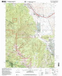
1998 Map of Park City West
USGS Topo · Published 2001About this map
Park City and the surrounding Wasatch mountain terrain are captured here just as the region prepared for its role as a global winter sports destination. The map records the transition from a historic mining hub to a recreational powerhouse, documenting the footprints of the Utah Olympic Park and the Park City Mountain Resort. While modern infrastructure like The Factory Stores and Parleys Park School appear, the area's industrial roots remain visible through labels for the Silver King Mine, Creole Tunnel, and Spiro Tunnel.
Find a feature on this map
60 named features on this map. Tap any name to fly to it.
Don’t see what you’re looking for? This feature index may not catch every label — zoom into the map to look around manually.
Map Details
Editions of this 1998 Park City West Map
This is the sole edition of this map. No revisions or reprints were ever made.
Other maps of this area

1885 · Salt Lake
USGS Topo · 1:250,000

1900 · Coalville
USGS Topo · 1:125,000

1903 · Coalville
USGS Topo · 1:125,000

1925 · Ft. Douglas
USGS Topo · 1:125,000

1928 · Ft. Douglas
USGS Topo · 1:125,000

1954 · Salt Lake City
USGS Topo · 1:250,000

1955 · Heber
USGS Topo · 1:24,000

1955 · Park City East
USGS Topo · 1:24,000

1955 · Brighton
USGS Topo · 1:24,000

1955 · Mount Aire
USGS Topo · 1:24,000