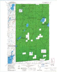
1968 Map of Park Falls SE
USGS Topo · Published 1985About this map
Chequamegon National Forest dominates this northern Wisconsin landscape, characterized by an extensive network of managed wetlands and glacial water bodies. The conservation priorities of the mid-20th century are evident in the designated habitats of the Upper Squaw Creek Waterfowl Area, Lower Squaw Creek Waterfowl Area, and the Schmuland Waterfowl Area. These protected zones, alongside features like Cranberry Bog and Hogsback Springs, illustrate the region's focus on preserving diverse aquatic ecosystems within the Park Falls Ranger District.
Find a feature on this map
23 named features on this map. Tap any name to fly to it.
Don’t see what you’re looking for? This feature index may not catch every label — zoom into the map to look around manually.
Map Details
Editions of this 1968 Park Falls SE Map
This is the sole edition of this map. No revisions or reprints were ever made.
Other maps of this area

1941 · Park Falls
USGS Topo · 1:48,000

1941 · Pike Lake
USGS Topo · 1:48,000

1941 · Phillips
USGS Topo · 1:48,000

1941 · Brantwood
USGS Topo · 1:48,000

1942 · Pike Lake
USGS Topo · 1:48,000

1943 · Park Falls
USGS Topo · 1:48,000

1943 · Philliips
USGS Topo · 1:48,000

1943 · Brantwood
USGS Topo · 1:48,000

1947 · Park Falls
USGS Topo · 1:48,000

1950 · Pike Lake
USGS Topo · 1:48,000