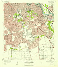
1955 Map of Park Place
USGS Topo · Published 1957About this map
Buffalo Bayou and the Houston Ship Channel dominate the industrial and residential expansion of southeast Houston during the mid-1950s. This survey captures a landscape of rapid transition, where the heavy rail infrastructure of the Port Terminal RR and Southern Pacific RR supports the shipping docks near Brady Island. Away from the industrial waterfront, neighborhoods like Park Place and Garden Villas are shown in full detail, alongside academic centers including the University of Houston and Texas Southern University.
Find a feature on this map
84 named features on this map. Tap any name to fly to it.
Don’t see what you’re looking for? This feature index may not catch every label — zoom into the map to look around manually.
Map Details
Editions of this 1955 Park Place Map
This is the sole edition of this map. No revisions or reprints were ever made.
Other maps of this area

1915 · Bellaire
USGS Topo · 1:24,000

1915 · Park Place
USGS Topo · 1:24,000

1915 · Houston Heights
USGS Topo · 1:24,000

1915 · Deepwater
USGS Topo · 1:24,000

1916 · Genoa
USGS Topo · 1:24,000

1916 · Settegast
USGS Topo · 1:24,000

1916 · Fauna
USGS Topo · 1:24,000

1919 · Deepwater
USGS Topo · 1:31,680

1920 · Genoa
USGS Topo · 1:31,680
1920 · Fauna
USGS Topo · 1:31,680