
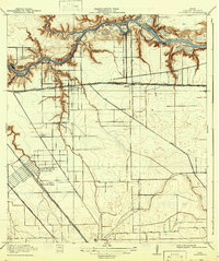
1919 Map of Deepwater
USGS Topo · Published 1919About this map
Buffalo Bayou and the developing Ship Channel dominate this Harris County landscape, showing the industrial and maritime foundations of the Houston area during the late 1910s. The map illustrates a transitional period where rural bayou land was being subdivided for rail-dependent settlements and shipping infrastructure. Along the northern waterfront, the Penn City Ferry and Penn City School serve the nascent Penn City community, while Irish Island and Irish Bend remain prominent natural features in the channel.
Find a feature on this map
35 named features on this map. Tap any name to fly to it.
Don’t see what you’re looking for? This feature index may not catch every label — zoom into the map to look around manually.
Map Details
Editions of this 1919 Deepwater Map
2 editions found
Other maps of this area

1915 · Park Place
USGS Topo · 1:24,000

1915 · Deepwater
USGS Topo · 1:24,000

1916 · Genoa
USGS Topo · 1:24,000

1916 · Burnett Bay
USGS Topo · 1:24,000

1916 · Settegast
USGS Topo · 1:24,000

1916 · Seabrook
USGS Topo · 1:24,000

1916 · Fauna
USGS Topo · 1:24,000

1916 · La Porte
USGS Topo · 1:24,000

1920 · Seabrook
USGS Topo · 1:31,680

1920 · Genoa
USGS Topo · 1:31,680