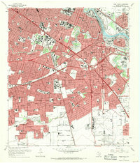
1967 Map of Park Place
USGS Topo · Published 1969About this map
Buffalo Bayou and its industrial Turning Basin anchor the northeast corner of this Southeast Houston landscape, illustrating the city's mid-century expansion toward the coast. The urban fabric is a dense network of neighborhoods like Park Place, Magnolia Park, and Riverside Terrace, intersected by the emerging Gulf Freeway and South Loop. This era marks a significant academic footprint for the region, with the large campuses of the University of Houston and Texas Southern University clearly defined. To the south, the massive layout of Houston International Airport dominates the map, bordered by drainage systems such as Sims Bayou and Berry Bayou. The map captures the transition from residential grids and schools like Sterling High Sch to the heavy shipping infrastructure along the ship channel, including the Manchester and Clinton Park districts.
Find a feature on this map
54 named features on this map. Tap any name to fly to it.
Don’t see what you’re looking for? This feature index may not catch every label — zoom into the map to look around manually.
Map Details
Editions of this 1967 Park Place Map
This is the sole edition of this map. No revisions or reprints were ever made.
Other maps of this area

1915 · Bellaire
USGS Topo · 1:24,000

1915 · Park Place
USGS Topo · 1:24,000

1915 · Houston Heights
USGS Topo · 1:24,000

1915 · Deepwater
USGS Topo · 1:24,000

1916 · Genoa
USGS Topo · 1:24,000

1916 · Settegast
USGS Topo · 1:24,000

1916 · Fauna
USGS Topo · 1:24,000

1919 · Deepwater
USGS Topo · 1:31,680

1920 · Genoa
USGS Topo · 1:31,680
1920 · Fauna
USGS Topo · 1:31,680