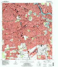
1995 Map of Park Place
USGS Topo · Published 1998About this map
Buffalo Bayou and the Houston Ship Channel dominate the northeast corridor of this survey, illustrating the industrial heart of southeast Houston. The landscape is a complex intersection of major transportation arteries and prominent educational institutions, including the campuses of Texas Southern University and the University of Houston. Residential patterns are visible in established neighborhoods like Park Place, Sunnyside, and Clinton Park, often bounded by the intensive rail networks of the Southern Pacific and Houston Belt and Terminal.
Find a feature on this map
48 named features on this map. Tap any name to fly to it.
Don’t see what you’re looking for? This feature index may not catch every label — zoom into the map to look around manually.
Map Details
Editions of this 1995 Park Place Map
This is the sole edition of this map. No revisions or reprints were ever made.
Other maps of this area

1915 · Bellaire
USGS Topo · 1:24,000

1915 · Park Place
USGS Topo · 1:24,000

1915 · Houston Heights
USGS Topo · 1:24,000

1915 · Deepwater
USGS Topo · 1:24,000

1916 · Genoa
USGS Topo · 1:24,000

1916 · Settegast
USGS Topo · 1:24,000

1916 · Fauna
USGS Topo · 1:24,000

1919 · Deepwater
USGS Topo · 1:31,680

1920 · Genoa
USGS Topo · 1:31,680
1920 · Fauna
USGS Topo · 1:31,680