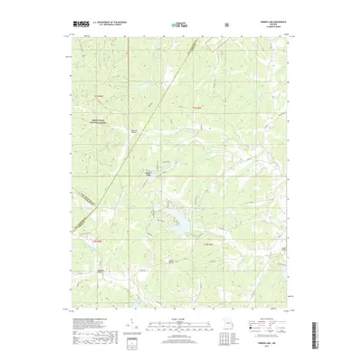
2017 Map of Parker Lake
USGS Topo · Published 2017About this map
Mark Twain National Forest dominates the western landscape of this Missouri quadrangle, where the borders of Perry, Ste. Genevieve, and St. Francois counties converge. The terrain is defined by a dense network of seasonal drainages and named hollows, including Thompson Hollow and Anderson Hollow, which feed into larger watercourses such as Brushy Cr and S Fork Saline Cr. The 2017 survey reveals a particular focus on private water management and recreation, evidenced by several artificial reservoirs like Parker Lake and Port Perry Number 2 Lake. These lakes are surrounded by a developing grid of rural residential roads, such as Erie Trail Dr and Lake Point Dr, contrasting with the more primitive tracks found deeper within the forest. Geologists and local land managers can trace the complex drainage patterns of Nations Cr and Upper Whitewater Cr as they cut through the Ozark foothills.
Find a feature on this map
68 named features on this map. Tap any name to fly to it.
Don’t see what you’re looking for? This feature index may not catch every label — zoom into the map to look around manually.
Map Details
Editions of this 2017 Parker Lake Map
This is the sole edition of this map. No revisions or reprints were ever made.
Other maps of this area

1907 · Weingarten
USGS Topo · 1:62,500

1909 · Weingarten
USGS Topo · 1:62,500

1910 · Higdon
USGS Topo · 1:62,500

1915 · Chester
USGS Topo · 1:62,500

1923 · Perryville
USGS Topo · 1:62,500

1924 · Perryville
USGS Topo · 1:62,500

1947 · Chester
USGS Topo · 1:62,500

1949 · Paducah
USGS Topo · 1:250,000

1949 · Rolla
USGS Topo · 1:250,000

1950 · Paducah
USGS Topo · 1:250,000