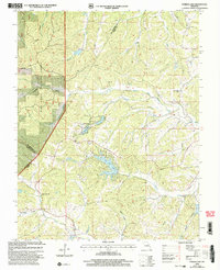
2000 Map of Parker Lake
USGS Topo · Published 2003About this map
Parker Lake and the engineered waters of Port Perry Lake anchor this rural landscape where the boundaries of Ste. Genevieve, Perry, and St. Francois counties converge. The terrain is defined by a dense network of drainages including Saline Creek, Nations Creek, and the Whitewater River, with much of the western portion preserved within the Mark Twain National Forest. Local history is grounded in dispersed community sites such as Cedar Grove Ch and Whitewater Ch. The prevalence of small rural educational centers, including May Sch, Baudendistel Sch, and Walnut Grove Sch, indicates a long-standing pattern of agricultural settlement. The map also documents modern infrastructure, such as a major pipeline corridor cutting through the southeastern hills near Dutch Hollow.
Find a feature on this map
31 named features on this map. Tap any name to fly to it.
Don’t see what you’re looking for? This feature index may not catch every label — zoom into the map to look around manually.
Map Details
Editions of this 2000 Parker Lake Map
This is the sole edition of this map. No revisions or reprints were ever made.
Other maps of this area

1907 · Weingarten
USGS Topo · 1:62,500

1909 · Weingarten
USGS Topo · 1:62,500

1910 · Higdon
USGS Topo · 1:62,500

1915 · Chester
USGS Topo · 1:62,500

1923 · Perryville
USGS Topo · 1:62,500

1924 · Perryville
USGS Topo · 1:62,500

1947 · Chester
USGS Topo · 1:62,500

1949 · Paducah
USGS Topo · 1:250,000

1949 · Rolla
USGS Topo · 1:250,000

1950 · Paducah
USGS Topo · 1:250,000