
1943 Map of Parker
USGS Topo · Published 1943About this map
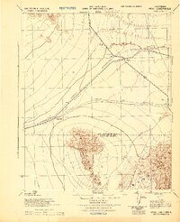
The Colorado River serves as the dominant geographic and jurisdictional spine of this region, separating the sharp relief of the desert uplands from the flat alluvial lands of the Colorado River Indian Reservation. Centered on the town of Parker, the map illustrates a vital transportation node during the Second World War, where the Santa Fe, Prescott & Phoenix R. R. crosses the water. To the south, the settlement of Agency and the riverfront point at Doyles Landing mark the early development of the reservation lands. The survey also traces significant surveying markers, including the San Bernardino Base Line and the county boundary between Yuma County and its northern neighbors, providing a detailed look at the rural landscape and rail stop at Denny before the extensive modern expansion of the Lower Colorado region.
Find a feature on this map
28 named features on this map. Tap any name to fly to it.
Don’t see what you’re looking for? This feature index may not catch every label — zoom into the map to look around manually.
Map Details
Editions of this 1943 Parker Map
This is the sole edition of this map. No revisions or reprints were ever made.
Other maps of this area

1911 · Parker
USGS Topo · 1:125,000

1930 · Linskey
USGS Topo · 1:62,500

1931 · Moon Mtn
USGS Topo · 1:62,500

1932 · Moon Mtn
USGS Topo · 1:62,500

1942 · Blythe
USGS Topo · 1:250,000

1942 · MOON MTN
USGS Topo · 1:62,500

1943 · Giers Basin
USGS Topo · 1:62,500

1943 · Whipple Mts.
USGS Topo · 1:62,500
1943 · Vidal
USGS Topo · 1:62,500

1945 · Big Maria Mtns
USGS Topo · 1:62,500