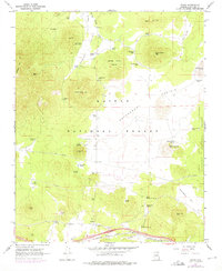
1966 Map of Parks
USGS Topo · Published 1975About this map
Parks and Maine anchor the southern corridor of this mid-century survey, situated along the critical route of the Atchison Topeka and Santa Fe Railway. The landscape transitions from the high peaks of Sitgreaves Mtn and Government Mtn down into the broad, open expanse of Government Prairie. Evidence of federal land management and military presence is prominent, with the Spring Valley Guard Station to the north and the northern edge of the Navajo Army Depot visible in the southeast. Numerous water sources, including Beale Spring and Kaufman Spring, alongside various tanks like Sego Tank, suggest a landscape historically reliant on these points for grazing and travel. Industrial activity is noted through several Cinder Pits and a network of pipelines that traverse the high-altitude terrain of the Kaibab National Forest.
Find a feature on this map
55 named features on this map. Tap any name to fly to it.
Don’t see what you’re looking for? This feature index may not catch every label — zoom into the map to look around manually.
Map Details
Editions of this 1966 Parks Map
4 editions found
Other maps of this area

1886 · San Francisco Mtns
USGS Topo · 1:250,000

1886 · Chino
USGS Topo · 1:250,000

1891 · San Francisco Mtns
USGS Topo · 1:250,000

1891 · Chino
USGS Topo · 1:250,000

1894 · San Francisco Mtns
USGS Topo · 1:250,000

1899 · San Francisco Mtns
USGS Topo · 1:250,000

1908 · Flagstaff
USGS Topo · 1:125,000

1912 · Flagstaff
USGS Topo · 1:125,000

1922 · Williams
USGS Topo · 1:125,000

1947 · Flagstaff
USGS Topo · 1:250,000