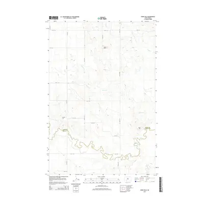
2014 Map of Parks Hills
USGS Topo · Published 2014About this map
Cedar Creek meanders deeply across the southern landscape of this Sioux County region, defining much of the border between the Grant and Sioux County lines. The terrain is characterized by significant rises such as Parks Hills in the southeast and Saddle Buttes to the north, providing natural landmarks in an area dominated by open range and a strict grid of section roads. Drainage for the northern high ground is channeled through the ephemeral paths of Crooked Cr and Whitmore Cr. While primarily rural, the map preserves the exact alignment of the local rural road network, including 90th St SW and 63rd Ave SW, which provide the skeleton for the sparse ranching and agricultural settlements in this part of North Dakota. Colville Hill stands as another prominent geographic marker, illustrating the varied elevations that define the local topography.
Find a feature on this map
16 named features on this map. Tap any name to fly to it.
Don’t see what you’re looking for? This feature index may not catch every label — zoom into the map to look around manually.
Map Details
Editions of this 2014 Parks Hills Map
This is the sole edition of this map. No revisions or reprints were ever made.
Other maps of this area

1953 · McIntosh
USGS Topo · 1:250,000

1954 · Bismarck
USGS Topo · 1:250,000

1958 · Bismarck
USGS Topo · 1:250,000

1958 · McIntosh
USGS Topo · 1:250,000

1972 · Paradise Flats
USGS Topo · 1:24,000

1972 · Wheeler Hills
USGS Topo · 1:24,000

1972 · Pretty Rock Butte
USGS Topo · 1:24,000

1972 · Morristown
USGS Topo · 1:24,000

1972 · Pretty Rock Butte SE
USGS Topo · 1:24,000
1972 · Keldron
USGS Topo · 1:24,000