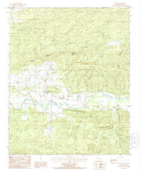
1985 Map of Parks
USGS Topo · Published 1986About this map
The Fourche La Fave River carves a central valley through this mid-1980s survey of western Arkansas, where the settlement of Parks serves as a local hub. The landscape is defined by the high ridges of the Ouachita National Forest, including the prominent Bill Hunt Mountain and Salt Log Mountain. These landforms dictate the settlement patterns, with roads and small farmsteads following the narrow corridors of level ground along Schoolhouse Ridge and the riverbanks.
Find a feature on this map
31 named features on this map. Tap any name to fly to it.
Don’t see what you’re looking for? This feature index may not catch every label — zoom into the map to look around manually.
Map Details
Editions of this 1985 Parks Map
This is the sole edition of this map. No revisions or reprints were ever made.
Other maps of this area

1879 · Poteau Mountain
USGS Topo · 1:62,500

1887 · Poteau Mountain #1
USGS Topo · 1:62,500

1887 · Mount Ida #2
USGS Topo · 1:62,500

1890 · Mount Ida
USGS Topo · 1:125,000

1890 · Poteau Mountain
USGS Topo · 1:125,000

1899 · Poteau Mountain
USGS Topo · 1:125,000

1939 · Waldron
USGS Topo · 1:62,500

1940 · Waldron
USGS Topo · 1:62,500

1941 · Waldron
USGS Topo · 1:62,500

1949 · Waldron
USGS Topo · 1:62,500