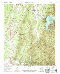
1966 Map of Parksville
USGS Topo · Published 1989About this map
Ocoee Lake (Parksville Lake) dominates the eastern landscape of this Tennessee valley, held back by the prominent Ocoee Dam No 1. The region is defined by a dense network of historical transportation routes, including the Old Federal Road, the Old Copper Road, and the Louisville and Nashville Railroad which runs through Oldfort and Conasauga. These corridors reflect the area's transition from a frontier thoroughfare to a managed industrial and recreational hub within the Cherokee National Forest.
Find a feature on this map
55 named features on this map. Tap any name to fly to it.
Don’t see what you’re looking for? This feature index may not catch every label — zoom into the map to look around manually.
Map Details
Editions of this 1966 Parksville Map
3 editions found
Other maps of this area

1886 · Dalton
USGS Topo · 1:125,000

1886 · Cleveland
USGS Topo · 1:125,000

1892 · Cleveland
USGS Topo · 1:125,000

1892 · Dalton
USGS Topo · 1:125,000

1895 · Cleveland
USGS Topo · 1:125,000

1897 · Dalton
USGS Topo · 1:125,000

1901 · Cleveland
USGS Topo · 1:125,000

1911 · Cohutta Mtn
USGS Topo · 1:62,500

1913 · Cohutta Mtn.
USGS Topo · 1:62,500

1935 · East Cleveland
USGS Topo · 1:24,000