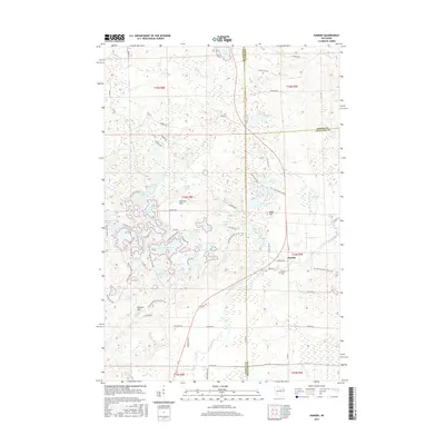
2015 Map of Parrish
USGS Topo · Published 2015About this map
Parrish sits at the eastern edge of the Harrison Hills, a glacial landscape dominated by dozens of kettle lakes and high moraine ridges. This 2015 survey reveals a terrain defined by water and woods, where names like Seven Island Lake, Turtle Lake, and Long Lake reflect the complex hydrology of northern Wisconsin. The Prairie River winds through the southern portion of the quadrangle, passing just below the Parrish Cemetery. The area is a significant corridor for recreation, as the Ice Age National Scenic Trail meanders across the southern hills, cresting at Lookout Mountain and Baldy Hill. The distribution of seasonal roads such as Cinder Rd and Shingle Mill Rd suggests a landscape largely managed for timber and conservation, centered on the tri-county border where Lincoln, Langlade, and Oneida counties meet.
Find a feature on this map
91 named features on this map. Tap any name to fly to it.
Don’t see what you’re looking for? This feature index may not catch every label — zoom into the map to look around manually.
Map Details
Editions of this 2015 Parrish Map
This is the sole edition of this map. No revisions or reprints were ever made.
Other maps of this area

1939 · Cassian
USGS Topo · 1:48,000

1940 · Parrish
USGS Topo · 1:48,000

1940 · Rhinelander
USGS Topo · 1:48,000

1942 · Cassian
USGS Topo · 1:48,000

1949 · Rhinelander
USGS Topo · 1:48,000

1950 · Parrish
USGS Topo · 1:48,000

1950 · Tomahawk
USGS Topo · 1:48,000

1952 · Parrish
USGS Topo · 1:48,000

1952 · Tomahawk
USGS Topo · 1:48,000

1954 · Iron Mountain
USGS Topo · 1:250,000