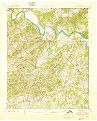
1940 Map of Parrottsville
USGS Topo · Published 1940About this map
The Nolichucky River carves a winding path through the borderlands of Greene and Cocke counties, defining a landscape of hollows and ridges just before the 1940s. The area around Parrottsville is deeply marked by early Tennessee settlement patterns, characterized by a high density of small community centers like Salem and Bruner Grove. This survey reveals a remarkably tight network of rural institutions, with dozens of family-named landmarks such as Ottinger Shelton Chapel, Jackson Chapel, and Love Memorial Ch serving isolated hollows.
Find a feature on this map
60 named features on this map. Tap any name to fly to it.
Don’t see what you’re looking for? This feature index may not catch every label — zoom into the map to look around manually.
Map Details
Editions of this 1940 Parrottsville Map
This is the sole edition of this map. No revisions or reprints were ever made.
Other maps of this area

1883 · Morristown
USGS Topo · 1:125,000

1892 · Greeneville
USGS Topo · 1:125,000

1893 · Mt Guyot
USGS Topo · 1:125,000

1893 · Morristown
USGS Topo · 1:125,000

1894 · Asheville
USGS Topo · 1:125,000

1895 · Morristown
USGS Topo · 1:125,000

1896 · Greeneville
USGS Topo · 1:125,000

1901 · Asheville
USGS Topo · 1:125,000

1904 · Greeneville
USGS Topo · 1:125,000

1912 · Mt Guyot
USGS Topo · 1:125,000