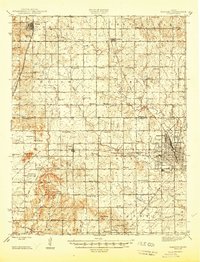
1946 Map of Parsons
USGS Topo · Published 1946About this map
Parsons anchors the southeastern corner of this Labette County survey, where the concentrated rail infrastructure of the Missouri Kansas Texas and St Louis San Francisco lines converges. The town's periphery includes the State Asylum, Orchard Park, and the Mt Calvary Cem, marking it as a significant regional hub just after the war. Beyond the city limits, the landscape transitions into a dense grid of rural school districts and cemeteries that reflect the settled agricultural character of the era.
Find a feature on this map
82 named features on this map. Tap any name to fly to it.
Don’t see what you’re looking for? This feature index may not catch every label — zoom into the map to look around manually.
Map Details
Editions of this 1946 Parsons Map
This is the sole edition of this map. No revisions or reprints were ever made.
Other maps of this area

1886 · Fredonia
USGS Topo · 1:125,000

1886 · Iola
USGS Topo · 1:125,000

1886 · Independence
USGS Topo · 1:125,000

1886 · Parsons
USGS Topo · 1:125,000
1893 · Iola
USGS Topo · 1:125,000

1893 · Parsons
USGS Topo · 1:125,000

1894 · Fredonia
USGS Topo · 1:125,000

1894 · Independence
USGS Topo · 1:125,000

1904 · Iola
USGS Topo · 1:125,000

1905 · Independence
USGS Topo · 1:125,000