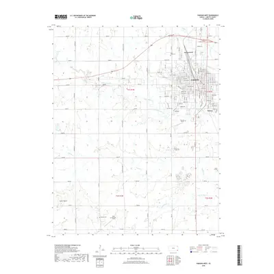
2018 Map of Parsons West
USGS Topo · Published 2018About this map
The city of Parsons anchors the eastern edge of this landscape, where the residential grids of Orchard Park and Winway meet the industrial infrastructure of the Union Pacific railroad. This 2018 survey reveals a transition from the urban density of Labette County's largest city to the structured agricultural expanses of the western prairie. Genealogists will find several significant burial grounds documented, including Mount Calvary Cem and Memorial Lawn Cem, while the rural western sections preserve older markers like Wilsonton Cem and Spring Hill Cem. Drainage patterns are defined by the winding paths of Little Labette Cr and Labette Creek, which carve through a terrain otherwise marked by prominent natural rises like Tackett Mound. Small-scale aviation history is also present, with Blue Sky Airport and Reed-Wilsonton Airport serving the area's transportation needs beyond the rail lines.
Find a feature on this map
116 named features on this map. Tap any name to fly to it.
Don’t see what you’re looking for? This feature index may not catch every label — zoom into the map to look around manually.
Map Details
Editions of this 2018 Parsons West Map
This is the sole edition of this map. No revisions or reprints were ever made.
Other maps of this area

1886 · Parsons
USGS Topo · 1:125,000

1893 · Parsons
USGS Topo · 1:125,000

1943 · McCune
USGS Topo · 1:62,500

1944 · Oswego
USGS Topo · 1:62,500

1945 · Mc Cune
USGS Topo · 1:62,500

1945 · Parsons
USGS Topo · 1:62,500

1946 · Oswego
USGS Topo · 1:48,000

1946 · Parsons
USGS Topo · 1:62,500

1946 · Mound Valley
USGS Topo · 1:62,500

1947 · Parsons
USGS Topo · 1:62,500