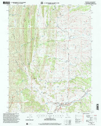
1995 Map of Paskenta
USGS Topo · Published 2001About this map
Thomes Creek flows along the southern edge of this landscape, anchoring a localized industrial and civic hub where the Crane Sawmill and its associated burner once operated. The map documents a transition from the agricultural flats near Rouse Gardens to the higher elevations of High Flat Ridge and Gordon Ridge. Between these heights, numerous drainages like Elder Creek and McCarty Creek carve through the terrain, punctuated by named summits such as Whitlock Butte and Owens Butte.
Find a feature on this map
37 named features on this map. Tap any name to fly to it.
Don’t see what you’re looking for? This feature index may not catch every label — zoom into the map to look around manually.
Map Details
Editions of this 1995 Paskenta Map
This is the sole edition of this map. No revisions or reprints were ever made.
Other maps of this area

1890 · Red Bluff
USGS Topo · 1:250,000

1894 · Red Bluff
USGS Topo · 1:250,000

1944 · Flournoy
USGS Topo · 1:62,500

1949 · Colyear Springs
USGS Topo · 1:62,500

1952 · Red Bank
USGS Topo · 1:24,000

1952 · Paskenta
USGS Topo · 1:62,500

1952 · Red Bank
USGS Topo · 1:62,500

1957 · Colyear Springs
USGS Topo · 1:62,500

1957 · Ukiah
USGS Topo · 1:250,000

1958 · Redding
USGS Topo · 1:250,000