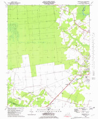
1982 Map of Pasquotank
USGS Topo · Published 1982About this map
The Great Dismal Swamp dominates the western half of this North Carolina survey, transitioning into the developed landscape of Elizabeth City and the Pasquotank River basin. This transition reflects the 1980s landscape where industrial and agricultural infrastructure, such as the Filtration Plant and various Radio Tower sites, operated alongside historic community centers. Local life centers on numerous small congregations and landmarks, including Berea Ch, Samuel Chapel, and the Drive-in Theater near the Albemarle Academy.
Find a feature on this map
31 named features on this map. Tap any name to fly to it.
Don’t see what you’re looking for? This feature index may not catch every label — zoom into the map to look around manually.
Map Details
Editions of this 1982 Pasquotank Map
This is the sole edition of this map. No revisions or reprints were ever made.
Other maps of this area

1906 · Hertford
USGS Topo · 1:62,500

1940 · Hertford
USGS Topo · 1:62,500

1940 · Wade Point
USGS Topo · 1:62,500

1940 · South Mills
USGS Topo · 1:62,500

1943 · Wade Point
USGS Topo · 1:62,500

1948 · Wade Point
USGS Topo · 1:62,500

1948 · Elizabeth City
USGS Topo · 1:62,500

1952 · South Mills
USGS Topo · 1:62,500

1953 · Norfolk
USGS Topo · 1:250,000

1982 · Nixonton
USGS Topo · 1:24,000