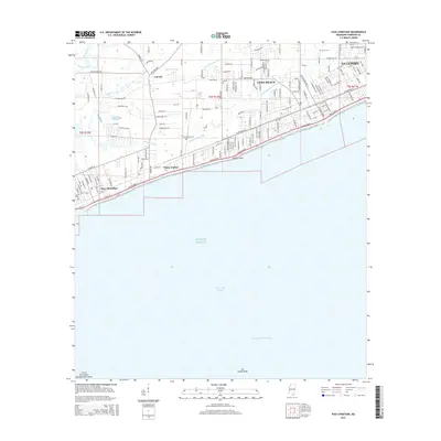
2015 Map of Pass Christian
USGS Topo · Published 2015About this map
Pass Christian and Long Beach anchor this coastal survey, where the Mississippi Sound meets the complex network of inland waterways. The landscape is defined by the proximity of Gulf of Mexico waters, with the Intracoastal Waterway running offshore and the Cat Island Shoal marking the southern maritime reaches. Inland, the hydrology is dominated by the Wolf River and Bayou Portage, while a series of man-made channels like Canal Number Three and Canal Number One indicate significant drainage and water management efforts across the coastal plain.
Find a feature on this map
174 named features on this map. Tap any name to fly to it.
Don’t see what you’re looking for? This feature index may not catch every label — zoom into the map to look around manually.
Map Details
Editions of this 2015 Pass Christian Map
This is the sole edition of this map. No revisions or reprints were ever made.
Other maps of this area

1893 · Cat Island
USGS Topo · 1:62,500

1893 · Toulme
USGS Topo · 1:62,500

1946 · Isle Au Pitre
USGS Topo · 1:31,680

1951 · Cat Island
USGS Topo · 1:24,000

1953 · Mobile
USGS Topo · 1:250,000

1954 · Isle Au Pitre
USGS Topo · 1:31,680

1954 · Gulfport North
USGS Topo · 1:24,000

1954 · Gulfport South
USGS Topo · 1:24,000

1955 · Pass Christian
USGS Topo · 1:24,000
1955 · Isle Au Pitre
USGS Topo · 1:24,000