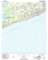
1994 Map of Pass Christian
USGS Topo · Published 1995About this map
The coastal landscape of Harrison County is defined by the dense residential and educational corridor along the Mississippi Sound in the early 1990s. The shoreline is characterized by the contiguous growth of Pass Christian and Long Beach, anchored by institutional landmarks such as the Univ Of Southern Miss (Gulf Park College) and the U S Naval Reservation. Further inland, the map captures a network of rural communities and crossroads, including Acadia and Cuevas, where local life centered around small churches like Our Lady Of Lourdes Ch and Antioch Ch. The drainage patterns of Wolf River and Portage Bayou contrast with the engineered drainage of CanAL No 1, reflecting the region's managed coastal plains. This era shows the developed waterfront just before significant modern changes, preserving the locations of legacy sites like the Courtenay Cem and Lumpkin Stadium.
Find a feature on this map
58 named features on this map. Tap any name to fly to it.
Don’t see what you’re looking for? This feature index may not catch every label — zoom into the map to look around manually.
Map Details
Editions of this 1994 Pass Christian Map
This is the sole edition of this map. No revisions or reprints were ever made.
Other maps of this area

1893 · Cat Island
USGS Topo · 1:62,500

1893 · Toulme
USGS Topo · 1:62,500

1946 · Isle Au Pitre
USGS Topo · 1:31,680

1951 · Cat Island
USGS Topo · 1:24,000

1953 · Mobile
USGS Topo · 1:250,000

1954 · Isle Au Pitre
USGS Topo · 1:31,680

1954 · Gulfport North
USGS Topo · 1:24,000

1954 · Gulfport South
USGS Topo · 1:24,000

1955 · Pass Christian
USGS Topo · 1:24,000
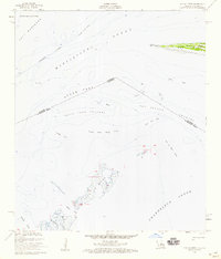
1955 · Isle Au Pitre
USGS Topo · 1:24,000