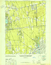
1947 Map of Patchogue
USGS Topo · Published 1947About this map
Patchogue and its surrounding south shore communities appear in high detail during the immediate post-war years, showcasing a landscape defined by traditional Long Island villages and early mid-century growth. The Long Island Railroad serves as the central spine of the region, connecting inland settlements like Holtsville and Medford to the busier coastal hubs. The transition between the Brookhaven and Islip townships is clearly visible, with the grid-pattern streets of Bohemia and Blue Point contrasting with the more sparse, woodland-dotted interior. Significant water features like Great Patchogue Lake and the western edge of Lake Ronkonkoma illustrate the natural geography that influenced early development and recreation. Local researchers will find a clear record of the region's road network, from established routes like Middle Country Road to more rural paths like Granny Road before the suburban expansion of later decades.
Find a feature on this map
38 named features on this map. Tap any name to fly to it.
Don’t see what you’re looking for? This feature index may not catch every label — zoom into the map to look around manually.
Map Details
Editions of this 1947 Patchogue Map
This is the sole edition of this map. No revisions or reprints were ever made.
Other maps of this area

1902 · Setauket
USGS Topo · 1:62,500

1902 · Fire Island
USGS Topo · 1:62,500

1903 · Fire Island
USGS Topo · 1:62,500

1904 · Setauket
USGS Topo · 1:62,500

1904 · Islip
USGS Topo · 1:125,000

1904 · Moriches
USGS Topo · 1:62,500

1919 · Setauket
USGS Topo · 1:62,500

1942 · Islip
USGS Topo · 1:125,000

1944 · Bay Shore East
USGS Topo · 1:24,000
1947 · St James
USGS Topo · 1:24,000