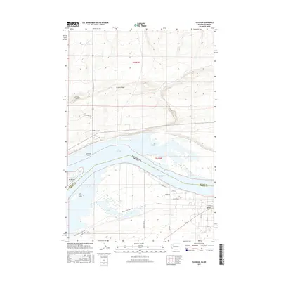
2017 Map of Paterson
USGS Topo · Published 2017About this map
Lake Umatilla dominates the center of this landscape, marking the state boundary between Washington and Oregon. Along the northern shore, the settlement of Paterson sits at the foot of Paterson Ridge, supported by local infrastructure including the Columbia Crest Winery Airport and Columbia Crst. The river environment is defined by a complex of islands and wetlands, such as Monument Island, Big Blalock Island, and the winding McCormack Slough. To the south, the city of Irrigon serves as a hub for the local road network, including Paterson Ferry Rd and Riverview Ln. This map captures a modern intersection of historical routes and contemporary agriculture, specifically noted by the Morrow Co Heritage Trail and the Umatilla Heritage Spur Trail which trace the land south of the water. The presence of the Irrigon Lower Range suggests the importance of river navigation and shoreline management in this reach of the Columbia River basin.
Find a feature on this map
34 named features on this map. Tap any name to fly to it.
Don’t see what you’re looking for? This feature index may not catch every label — zoom into the map to look around manually.
Map Details
Editions of this 2017 Paterson Map
This is the sole edition of this map. No revisions or reprints were ever made.
Other maps of this area

1906 · Blalock Island
USGS Topo · 1:125,000

1908 · Blalock Island
USGS Topo · 1:125,000

1908 · Umatilla
USGS Topo · 1:125,000

1915 · Prosser
USGS Topo · 1:125,000

1917 · Pasco
USGS Topo · 1:125,000

1917 · Prosser
USGS Topo · 1:125,000

1953 · Pendleton
USGS Topo · 1:250,000

1953 · Walla Walla
USGS Topo · 1:250,000

1956 · Pendleton
USGS Topo · 1:250,000

1958 · Walla Walla
USGS Topo · 1:250,000