1947 Map of Patillas NO
USGS Topo · Published 1947About this map
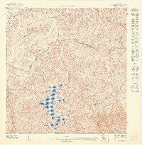
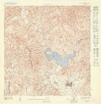
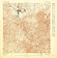
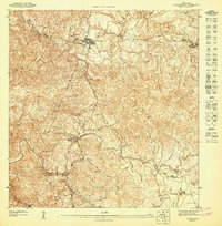
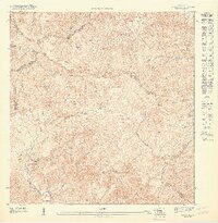
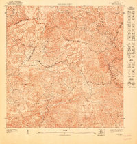
Lago Carite serves as a central hydrological feature in this mountainous interior region of Puerto Rico, where the municipal boundaries of Cayey, Guayama, and Patillas converge. The landscape is dominated by the Bosque Insular de Carite, a protected forest area characterized by significant elevation changes and the headwaters of the Rio de la Plata. This 1943 topography reveals the early 20th-century isolation of these highlands, with infrastructure limited to isolated outposts like Campamento Guavate and narrow transit routes such as Vereda Los Salchos. The dense contour lines illustrate the challenging geography surrounding Cerro Lucero, where deep valleys and steep ridges dictated the pattern of early settlement and land use prior to modern development. The map also traces the winding course of Quebrada Grande, highlighting the intricate network of streams feeding the reservoir.
Find a feature on this map
9 named features on this map. Tap any name to fly to it.
Don’t see what you’re looking for? This feature index may not catch every label — zoom into the map to look around manually.
Map Details
Editions of this 1947 Patillas NO Map
This is the sole edition of this map. No revisions or reprints were ever made.
Other maps of this area

1946 · Patillas
USGS Topo · 1:30,000

1946 · Cayey
USGS Topo · 1:30,000

1946 · Comerio
USGS Topo · 1:30,000

1946 · Caguas
USGS Topo · 1:30,000

1947 · Patillas SO
USGS Topo · 1:10,000
1947 · Patillas SE
USGS Topo · 1:10,000
1947 · Cayey NE
USGS Topo · 1:10,000
1947 · Comerio SE
USGS Topo · 1:10,000
1947 · Patillas NE
USGS Topo · 1:10,000
1947 · Cayey SE
USGS Topo · 1:10,000