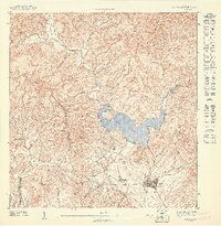
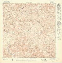
1947 Map of Patillas SE
USGS Topo · Published 1947About this map
The Lago Patillas reservoir dominates this southeast Puerto Rican landscape, acting as the hydrological anchor where the Río Grande de Patillas and the Río Marín converge. This 1943 survey, published in 1947, reveals a transition from the agricultural lowlands of Hacienda Felicita and the town of Patillas to the steep, rising interior. The terrain is defined by prominent peaks including Cerro Yaurel, Cerro Piedra Gorda, and the ominously named Cerro Boca del Infierno.
Find a feature on this map
18 named features on this map. Tap any name to fly to it.
Don’t see what you’re looking for? This feature index may not catch every label — zoom into the map to look around manually.
Map Details
Editions of this 1947 Patillas SE Map
This is the sole edition of this map. No revisions or reprints were ever made.
Other maps of this area

1945 · Punta Tuna
USGS Topo · 1:30,000

1946 · Patillas
USGS Topo · 1:30,000

1946 · Yabucoa
USGS Topo · 1:30,000

1946 · Guayama
USGS Topo · 1:30,000

1947 · Yabucoa SO
USGS Topo · 1:10,000

1947 · Patillas SO
USGS Topo · 1:10,000
1947 · Guayama NE
USGS Topo · 1:10,000
1947 · Punta Tuna NO
USGS Topo · 1:10,000
1947 · Guayama NO
USGS Topo · 1:10,000
1947 · Patillas NE
USGS Topo · 1:10,000