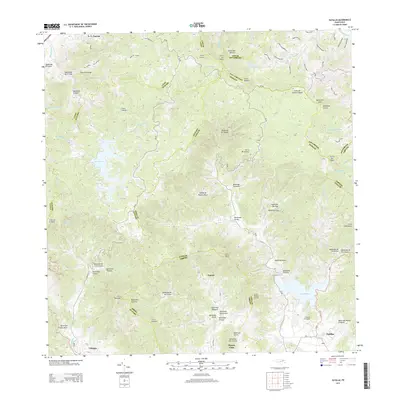
2013 Map of Patillas
USGS Topo · Published 2013About this map
Patillas and its rugged surrounding highlands are documented in this contemporary survey, which illustrates the complex drainage and elevation profile of the region. The landscape is defined by the headwaters of the Rio de la Plata and the significant reservoirs of Lago Carite and Lago Patillas, which serve as vital water resources for the area. The settlement pattern is largely concentrated in the lower elevations, where Yaurel, Olimpo, and Buena Vista are connected by a network of local roads and named paths such as Vereda Los Baldios. The map highlights numerous mountain peaks, including Cerro Lucero and Cerro Corazón, underscoring the topographic challenges of the southern Puerto Rican interior. Researchers can trace the myriad of small streams, or quebradas, such as Quebrada Yaurel and Quebrada Farallón, that flow through the valleys between steep ridges and the Island of Puerto Rico interior boundary lines.
Find a feature on this map
91 named features on this map. Tap any name to fly to it.
Don’t see what you’re looking for? This feature index may not catch every label — zoom into the map to look around manually.
Map Details
Editions of this 2013 Patillas Map
This is the sole edition of this map. No revisions or reprints were ever made.
Other maps of this area

1945 · Punta Tuna
USGS Topo · 1:30,000

1945 · Central Aguirre
USGS Topo · 1:30,000

1946 · Patillas
USGS Topo · 1:30,000

1946 · Cayey
USGS Topo · 1:30,000

1946 · Comerio
USGS Topo · 1:30,000

1946 · Juncos
USGS Topo · 1:30,000

1946 · Yabucoa
USGS Topo · 1:30,000

1946 · Guayama
USGS Topo · 1:30,000

1946 · Caguas
USGS Topo · 1:30,000

1947 · Yabucoa SO
USGS Topo · 1:10,000
Featured Places
- Patillas
- Sector Hormiga, Patillas
- Sector Los Meléndez, Cayey
- Sector Conejo Blanco, Patillas
- Villa Kike, San Lorenzo